Raul Yzaguirre School For Success (RYSS) - NASA International Space Station (ISS)
Raul Yzaguirre School For Success (RYSS) - NASA International Space Station (ISS) Photographs of Earth II [2012-2013]
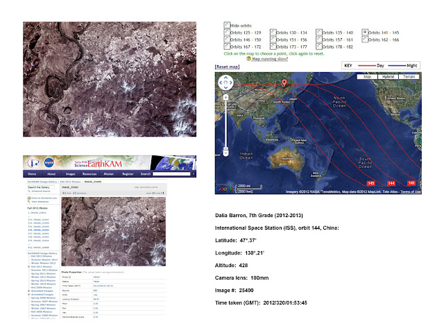
RYSS College Prep Academy students (grades 6 - 8 ) requested photographs of Earth from the NASA International Space Station via the EarthKAM (Earth Knowledge Acquired by Middle school students) mission program. They identified the locations on Earth via various orbital paths for the onboard camera to take their photographs.
The program is a NASA educational outreach program enabling students, teachers and the public to learn about Earth from the unique perspective of space. During EarthKAM missions (periods the EarthKAM camera is operational), middle school students around the world request photos of specific locations on Earth.
The project was initiated by Dr. Sally Ride (America's first woman in space) in 1995 and called KidSat. The KidSat camera flew on three space shuttle flights (STS 76, 81 and 86) to test its feasibility. In 1998, the program was deemed successful and renamed to EarthKAM. The EarthKAM camera flew on two additional space shuttle flights (STS 89 and 99) before moving over to the International Space Station (ISS) in 2001 on Expedition 1. The EarthKAM camera has since been a permanent payload on board the ISS and supports approximately four missions annually.
Students are seen below working with the EarthKAM website to choose their location for the camera on board the International Space Station to take their picture.
Longitude (shown as a vertical line) is the angular distance, in degrees, minutes, and seconds, of a point east or west of the Prime (Greenwich) Meridian. Lines of longitude are often referred to as meridians.
Distance between Lines If you divide the circumference of the earth (approximately 25,000 miles) by 360 degrees, the distance on the earth's surface for each one degree of latitude or longitude is just over 69 miles, or 111 km. Note: As you move north or south of the equator, the distance between the lines of longitude gets shorter until they actually meet at the poles. At 45 degrees N or S of the equator, one degree of longitude is about 49 miles.
Minutes and Seconds For precision purposes, degrees of longitude and latitude have been divided into minutes (') and seconds ("). There are 60 minutes in each degree. Each minute is divided into 60 seconds. Seconds can be further divided into tenths, hundredths, or even thousandths. (Worldatlas.com)
Orbit information:
The ISS orbits the Earth at 51.6° to the Equator, following the direction of the Earth’s rotation from west to east. The Earth itself is tilted at 23.4° to the plane of its orbit around the sun (sun vector), so the ISS is orbiting at 75° to the sun vector. The ISS’s altitude varies between 320 to 410 km, and it takes 92 minutes to circle the Earth. The orbit inclination offers good coverage of most of Earth’s surface.
ISS Camera information:
In conjunction with NASA and Sally Ride Science, a camera system has been installed on the International Space Station. This camera system is responsible for taking and downloading student image requests. The camera is mounted in a nadir pointing window on the ISS. EarthKAM is using the Nikon D2Xs Digital Camera, controlled by the Lenovo (IBM) T61p Laptop.
Examples of student photo/map layout:


Comments
Post a Comment